Tuesday, November 13, 2012

Whatchamacallit

Ok, ok, that's not its real name. We were supposed to stop at Karrat Fiord, but the wind and current were still against us, so we stopped at Whatchamacallit ... at least, that's what our Expedition Leader, Brad, called it! In reality, its name is Midtlorfik (Mitdlorfik?) ... couldn't find it on Google Maps, or on the Greenland Tourism website, so the marker here is an approximation:


View Arctic Cruise 2012 in a larger map

The sun was shining, but it was windy, which made the zodiac trip a bit miserable. But the time ashore made it all worth it! The beach was of large rounded pebbles, a tricky crossing, then directly onto deep peat.

The going was very wet in places, and you really had to watch your step as there were deep gaps between the "high and (relatively) dry" parts of the peat, and knee/thigh deep gullies with ankle-deep muck waiting to suck a boot off!

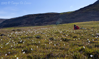
I think everyone was need a bit of space as the entire party just scattered! It was a pleasant stop. I got obsessed with photographing the Arctic cotton (cotton grass) ... as you'll see ...




Animated banner ad

Saturday, November 10, 2012

Of Explorers and Meteors

Today we visit Kap York:


View Arctic Cruise 2012 in a larger map
Yesterday afternoon, after almost falling off a bar stool falling asleep during an afternoon lecture session, I went to the cabin and caught up on some sleep. I've no idea how long I slept, but my roomie said I was out cold when she came in - I never heard a thing! As always happens when I sleep during the day, I felt terrible after I awoke. I decided to get some fresh air so I grabbed my camera bag and a mug of tea, and headed to what's by now my regular station on the top viewing deck. I ended up skipping dinner altogether, just grabbing more tea and a couple of bikkies before heading below for the night.

Despite having slept during the day, I had another great night's sleep and we arrived at our next destination, Kap York, under the now-customary dreary skies early this morning. But it wasn't raining or snowing, so we weren't complaining too loudly!

Kap York is another of Peary's expedition bases, but is possibly more notable as the location of three iron-rich meteors! In the usual manner of the time, Peary promptly took all three of the megaton meteors back to New York - probably to prove to the expeditions' sponsors that he really was doing some useful scientific research in the Arctic! One wonders what the Inuit reaction to this theft was, considering that they'd started utilizing various forms of the ore. None of the meteors has ever been returned, either.

There wasn't a great deal to see here in the way of relics of past settlements, but it was scenic and we were able to take the zodiac close to some magnificent icebergs on our way back to the ship (difficult to take photos - very splashy and bumpy). As with other places we've visited on this journey, it struck me again how very difficult it is to imagine anyone living here year round, particularly with the absence of modern communications - or fleece and goretex!


Animated banner ad

Saturday, November 3, 2012

On to Greenland!

You've heard it said that the road to hell is paved with good intentions? Well, they're right! I'd intended (there's that word!) to post at least once a week until I'd covered my entire Arctic cruise ... and I think its been a month since my last entry!

Calmer oceans now, as we cross the passage to Greenland! And surprisingly green, it is!


View Arctic Cruise 2012 in a larger map

Etah sits at the head of a pretty fjord, about a 30 minute zodiac ride from where the Clipper dropped anchor. It isn't permanently occupied these days, although it used to have year-round residents. Today its used as a base for hunting walrus, muskox, and caribou, more than anything else.

Both the Peary (in the late 1800's) and the Cook expeditions used this spot as a staging point for their assaults on the north pole.

During our cruise from ship to shore, we spotted muskox, but they're very shy - understandably, due to the presence of several hunting camps along the shoreline. We saw snow geese ashore, too, but couldn't get within pixel-range (at least, with my 200mm lens).

I could've walked to the toe of a glacier, about 1.5km from the shore, but was starting to get twitchy at being constantly surrounded by people and most others were doing that, so struck out on my own. Here are some of my favourite photos from the hike:


Animated banner ad